Category Archives: Maps

If you have a map – whether it is a GPS file or a document, you should post it in here.

2013 Pedaling The Prairie – Hempstead, TX – 24, 45, 55, 71 mile routes

2013 Pedaling The Prairie – Hempstead, TX – 24, 45, 55, 71 mile routes

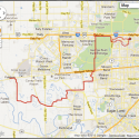
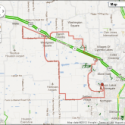
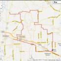
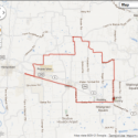
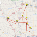
This map has all track routes included; if you want the individual TCX files, visit the Ready2Roll Cycling site and check under Communications–>Houston–>Maps.

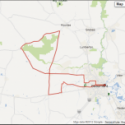
This is a relatively flat route with some rollers and the annual event is pretty large – be forewarned.

[map style=”width: auto; height:600px; margin:20px 0px 20px 0px; border: 2px solid black;” maptype=”OSM” gpx=”https://www.keeponpedaling.com/wp-content/uploads/03 – Pedaling the Prairie.gpx”]

Chappell Hill Loop – Chapell Hill, TX – 56 miles

Chappell Hill Loop – Chapell Hill, TX – 56 miles

[map style=”width: 600px; height:500px; margin:20px 20px 20px 20px; border: 2px solid black;” maptype=”ROADMAP” bike=”yes” gpx=”https://www.keeponpedaling.com/wp-content/uploads/12_31_2011 Chappell Hill, TX(1).gpx”] Printable Map Here:  Chappell Hill Loop Click on the Download link above for the GPX file. Continue Reading

Spindletop Spin Century – Beaumont, TX – 100 miles

Spindletop Spin Century – Beaumont, TX – 100 miles

[map style=”width: 600; height:500px; margin:20px 20px 20px 20px; border: 2px solid black;” maptype=”ROADMAP” bike=”yes” gpx=”https://www.keeponpedaling.com/wp-content/uploads/Cyclemeter-Cycle-20120602-0644.gpx”] A printable map is here:  2012 Spindletop Spin Map Click on the Download link above for the GPX file. Continue Reading